Description
Linking neighborhoods throughout the southern districts of Minneapolis, a former rail right-of-way has been transformed into a major recreational greenway much beloved by residents and workers. Along the Midtown Greenway, new development has been springing up since the construction of phase one in 2000. The […]
DESCRIPTION
Clear Creek Transit Village is a TOD located on the Gold Line of the Denver Metro Area FasTracks program. The Gold Line is slated to start construction in late 2010 and open to the public in 2016. Located in unincorporated Adams County, this site would […]
DESCRIPTION
Ensemble Station represents a catalyst for Transit Oriented Development for the city of Houston. Working in collaboration with the Environmental Protection Agency and the people of Houston, this site attempts to create not only a financially viable neighborhood for both land owners and occupants, but […]
DESCRIPTION
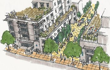
Working with TransAct, VMWP was charged to identify and evaluate potential development alternatives to enrich the historic Letterman and Thornburgh Districts of the Presidio through suitable adaptive reuse, enhanced retail amenities, “third place” spaces for social interaction, transportation management, and sustainable infrastructure, to define critical […]
description
Belmar is the redevelopment of a failed 1960’s 100 acre enclosed shopping mall into a vibrant urban village. The site is bordered by two high volume state highways adjacent to Lakewood’s civic center, community park and single family neighborhoods. The urban design is organized as […]
description
Ho’opili presents an implementable vision for a 1,600 acre transitoriented community in the quickly urbanizing Ewa district of western Oahu. The plan focuses future growth around a series of transit stations while providing a wide variety of community amenities such as a mix of uses, […]
DESCRIPTION
Northgate Center is a 65-acre site at the intersection of Federal Boulevard and West 72nd Avenue. The area is in need of a wider variety of housing options to support the proposed commuter rail stop that will be 1/2 mile to the west of the […]
DESCRIPTION
The vision for the Fannin Station TOD is one of connecting a series of properties into the redevelopment of a mixed-use, transit oriented district, made up of a variety of neighborhoods centered around pedestrian-oriented places. The existing Main Street light rail line and transit stop […]
DESCRIPTION
Waipahu Neighborhood TOD is two community plans for the siting and future urban redevelopment adjacent to the planned elevated fixed guideway transit system for the island of Oahu. This culturally diverse neighborhood is an historical plantation center. Waipahu is located just north of Pearl Harbor […]
DESCRIPTION
The Visitacion Valley/Schlage Lock Master Plan redevelops the 20- acre brownfield site into a vibrant mixed-use and transit-oriented neighborhood. The project is at the southern edge of San Francisco and the northern end of the future Baylands development. The new neighborhood extends the city grid […]
 Lynlake Capacity Study
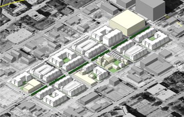 Ensemble Station
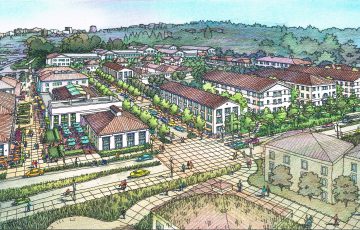 West Letterman Development Study
 Belmar Master Plan
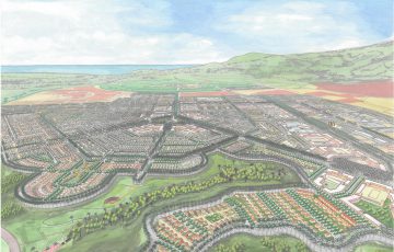 Ho’opili Master Plan
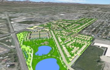 Northgate Center
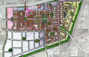 Fannin Station TOD
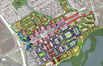 Waipahu Neighborhood TOD
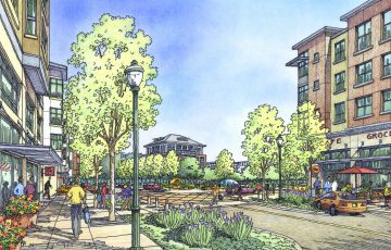 Schlage Lock Master Plan